Tuesday, October 14, 2008

Pupfish Population Increasing


Photo by Stephen Osmon, Los Angeles Times


We wrote about the incredibly rare Death Valley pupfish last year, after we saw them in their tiny Devils Hole habitat in Nevada. Now the New York Times and the Los Angeles Times report that the fall count of the pupfish shows an increase in population. The pupfish, an isolated species whose numbers were down as low as 38 in 2006, now number 126. They numbered close to 500 as recently as the mid-1990s.

The counts are done in spring and fall; spring counts are typically much smaller than fall because the pupfish have a greater die off in the winter months. They are counted in the shallow rock shelf where the majority of them feed and spawn, and by divers who reach the 100 foot depths where others may swim. They are counted twice a day, and the numbers averaged for a total population figure

Biologists are not sure why the species has dwindled so precipitously since then, but suspect that a lack of nutrients is to blame. To remedy the situation, they took the highly unusual step of developing a specialized, high-nutrient fish food similar to food used to feed minnow at a New Mexico hatchery.

"It was not done lightly," Bob Williams, Nevada field supervisor for the U.S. Fish and Wildlife Service, told the L.A. Times. "When you start to artificially augment a wild population, it is a sign the species is really in trouble."

Click here for more information on the Amargosa Valley pupfish station or the pupfish home page at http://www.fws.gov/Nevada/protected_species/fish/species/dhp/dhp.html.

Sunday, September 21, 2008

Imperial Beach

Located very close to the California-Mexican border, Imperial Beach is the southwestern-most city in the United States, a small, unpretentious beach town not nearly as affluent or well-known as Coronado. Which is probably how they like it.


Located close to the beach is the Tijuana Estuary Visitor Center, where there are miles of trails and abundant bird-watching.

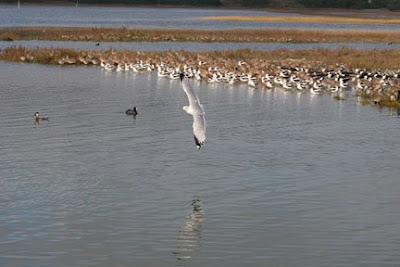
We had the reserve to ourselves, except for a birder who had already spent the entire morning waiting to see something. He became very excited by the appearance of a rare bird, which he pointed out to us (seen below). We have to admit, rather sheepishly, that we are not birders and therefore don't know how momentous viewing this bird was. We also can't say what it was (although it may have been a bar-tailed godwit). If anyone can positively identify this bird, please let us know.


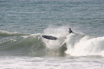
Walking across to the uncrowded beach, we came across one of those scenes that defines the archetype of Southern California--surfers. One had brought his black Lab, who was ecstatic to get out in the water, rush back to shore, and repeat the process. He may have had a better time than his master, who wiped out.


Wednesday, September 3, 2008

Card of the Week: Ashford Mill, Death Valley


It might sound odd, but Death Valley is one of the most beautiful places on Earth, and one of our favorite spots to visit. Despite its funereal name, there is plenty of life in this extreme environment. Even a little bit of rain can spur a bloom. Here is an abandoned mine now full of the wildflower desert gold.

This is one of our most popular cards. It is available for $2 each, with free shipping. A pack of 10 costs $16. To order, please contact us at info@mozaicstudio.com.

Monday, August 25, 2008

Card of the Week: Leaning Tree


Here's a new feature for our blog: Card of the Week, where we showcase some of our best cards. This one, "Leaning Tree," was shot at Maroon Bells, Aspen, Colorado.

Mozaic Studio cards are printed on recycled paper, and available for $2 each, with free shipping. Packs of 10 are only $16. To order, please contact us at info@mozaicstudio.com.

Sunday, August 24, 2008

PickensPlan


Visit PickensPlan

View my page on PickensPlan


We've been all though the U.S., mostly on road trips through national parks, vast deserts, along Route 66, in sequoia forests, deep gorges, across wild rivers, and in parts in-between. This is a beautiful and amazing country full of ecological treasures. To diminish any of it is to lower our quality of life here.

At the same time, we must come to terms with our gross and ruinous reliance on oil--particularly foreign oil--as the fuel that keeps us moving. America must reduce, if not eliminate, this reliance. We have joined other proponents of the PickensPlan in urging the increase of wind power as a source of energy. It's clean, it's environmentally friendly, and it doesn't require despoiling anything to get it.

You can be cynical and protest that T. Boone Pickens, the plan's chief architect, stands to profit financially from any increase in wind power, and that his main motivation is the bottom line in his own fortune. Personally, we would rather hand our fuel dollar over to another American than to some hostile petro-billionaire who despises us. You can also dismiss wind power as a micro-solution that won't replace anything. We would argue that the long journey to fuel independence must start somewhere, however modest.

Check out the PickensPlan. Better yet, join. Since American leaders can only suggest offshore drilling as the answer to the current fuel crisis--oh, right, let's not change anything about what we use, let's just change where we can get more of it--take matters into your own hands and join a movement.

Friday, July 25, 2008

Wildlife Coming Back at Mono Lake

The Los Angeles Times is reporting that the restoration of Mono Lake has led to a burgeoning recovery of lake wildlife.

Mono Lake, located in Central California near Bishop, was drained and nearly destroyed when the water from tributary streams was diverted to Los Angeles by the city's Department of Water and Power. The lack of fresh water left the lake with deadly salinity levels and created salt flat dust storms. The Save Mono Lake conservation group sued the DWP in 1978, and California courts ordered Los Angeles to reduce its water diversion.

While the lake is still below a normal level, and the Save Mono Lake group still believes it has "a long way to go," the tributaries have fostered newly lush grasses and other riparian vegetation. Trout, warblers and other birds have returned to Mono, and it seems to be on its way back to life.

Newport Back Bay


Rich and flashy Newport Beach might seem an unlikely place for a wildlife refuge, but it is, in fact, a critical estuary habitat for migratory birds. An estuary is where fresh and salt water mix, as in a creek meeting the sea. It is one of the few remaining estuaries in Southern California.


The Upper Bay, or "Back Bay," located on Back Bay Drive just off of the Pacific Coast Highway at Jamboree, is a 752-acre ecological preserve surrounded by bluffs. The California gnatcatcher, the cactus wren, the brown pelican, and the California least tern are among the rare or endangered birds that feed from or inhabit the bay. During the winter migration, as many as 30,000 birds use the bay as a stopover, making it a major bird-watching spot for minimal effort. The bay also has the Peter & Mary Muth Interpretive Center, and Back Bay Science Center.


The Back Bay is easy to reach by car or bike, and has a (one way) road that will take you from end to the other. It is a popular place year-round for walkers, joggers, painters, bike riders, bird watchers, nature lovers, and photographers. For more information, check out http://www.newportbay.org.

Thursday, May 15, 2008

Desert Tortoise Relocation Plan Failing

A $8.7 million plan by the U.S. Army to relocate endangered California desert tortoises from Ft. Irwin has failed to adequately protect them, according to an environmental group.

The Center for Biodiversity in Tucson is suing the Army, the U.S. Fish and Wildlife Service and the Bureau of Land Management for allegedly violating the federal Endangered Species Act in the relocation effort.

Coyotes have killed an estimated 14 relocated tortoises, which are monitored and tracked by radio transmitters. Drought is believed to have reduced the number of rabbits that coyotes normally prey on, driving them increasingly to attack tortoises whose shells cannot completely protect them. Additionally, an infectious disease spread at a relocation training center is being blamed for the deaths of 15 baby tortoises.

The relocation was in response to the expansion of Ft. Irwin, which included the development of prime desert tortoise habitat. To protect the endangered species, the Army captured and airlifted about 760 tortoises from Ft. Irwin to public lands in the Mojave Desert near Barstow, California.

Environmental groups had warned the Army that relocating the tortoise exposed them to a number of threats, including drought-stricken foraging grounds, respitory disease, and attacks by coyotes, dogs, and ravens. For its part, the Army believed that leaving the tortoises at Fort Irwin exposed them to worse vehicular dangers, and has plans to trap and kill what it calls “a rogue band of coyotes.”

The Army has plans to relocate an additional 1200 tortoises.

Thursday, May 8, 2008

Tejon Development and Conservation


The Los Angeles Times is reporting today that a deal has been reached between developers and environmental groups that will allow the building of 26,000 new homes on pristine land owned by the Tejon Ranch Co. in exchange for the conservation of 178,000 remaining acres. It will also allow the public purchase of an additional 49,000 acres for a public park.

The Tejon Ranch is 270,000 acres of land 60 miles north of Los Angeles that is spread over Los Angeles and Kern counties, and which covers four distinct ecosystems: Mojave Desert grasslands, San Joaquin Valley oak woodlands, Tehachapi pine forests and coastal mountain ranges. It is also the habitat for the highly endangered and federally protected California condor. Part of the agreement called for the new homes to be built away from the ridgelines where the condors forage. Developers had previously sought a waiver from the government to be relieved of legal responsibility if land development resulted in a condor's death.

Other wildlife inhabiting the ranch land include bobcats, deer, coyotes, golden eagles, elk and wild turkey. A spokesman for the Sierra Club has declared it "the ecological equivalent of the Louisiana Purchase" for Southern California.

The houses will be built in the southern portion of the ranch, while an industrial complex has already gotten underway in the western-most corner, just south of where Interstate 5 forks off to the beginning of Highway 99. In addition to the objections from environmental groups concerned about wildlife, other complaints about the development were that Southern California sprawl was creeping into Central California.

Given the seemingly inexhaustible demand for new houses in Southern California, it was inevitable that one of the last great pieces of undeveloped land in the state would be carved up for housing. This may be the best deal possible to avoid losing all the land to cities and shopping malls. But with the housing bubble burst, and gas only getting more prohibitive in cost, who is going to commute 60 miles one way to L.A?

Friday, February 22, 2008

La Jolla


It's easy to pass a weekend in La Jolla, where you can walk along the beach, see the sea lions lounging on the sand, have your pick of good restaurants, do some shopping, and enjoy the sea breezes.


I especially liked watching the sea lions, taking an nap en masse on the beach, soaking up the sun before going back out into the water. Their faces are sweet, and the apparent laziness reminds you of a certain kind of pet at home.

Tuesday, February 19, 2008

Bristlecone Pines

A bristlecone pine shown against the stark desert-like background of the forest, and a shot of the smooth, wind-shaped bristlecone bark.


Monday, February 18, 2008

The Ancient Bristlecone Pine Forest


Located about 10,000 feet up in the White Mountains, about an hour outside of Bishop, California, the ancient bristlecone pines are the oldest living things on Earth. The oldest tree, nicknamed "Methusaleh," is over 4,700 years old, although there may be trees yet to be identified which are older. The trees' true age wasn't determined until the 1950s by biologist Edmund Schulman, who examined tree rings. A grove of the trees has been named in his honor at the Ancient Bristlecone Pine Forest Inyo National Forest. The bristlecones exist only in the White Mountains, a mountain range smaller and much drier than the Sierra Nevada. The lack of rain, the rocky soil (which looks more like decorative rock chips than soil), and intense cold all combine to limit the pines' growing season, and they may only grow a fraction of an inch per decade. High winds twist and polish the trees so that they usually have a stark, broken appearance with smooth bark of variations in color from white to brown to black.


Some of the trees are accessible by hiking trails through the Ancient Bristlecone Pine Forest Inyo National Forest. Methusaleh's exact spot is concealed for its protection, but they are all mind-bogglingly old. They are fascinating, oddly beautiful trees in a dry, oddly beautiful desert-like forest. Snow may keep you out for part of the year, and it can be cold well into spring. Definitely worth a trip if you are in the area.

Wednesday, January 16, 2008

A Brief History of Malta


Malta has been inhabited for over 7000 years, since Neolithic times. After the Neolithic civilization disappeared around 2000 BC, the islands were conquered by Phoenicians and Romans.

After St. Paul was shipwrecked on Malta in 60 AD, he converted the island to Christianity, and with the exception of a brief period of Arab occupation in 870 AD, Malta has remained Christian ever since. Norman Sicilians took Malta from the Arabs in 1090 and occupied it until 1530, when Charles V handed Malta over to the Order of Knights of the Hospital of St. John of Jerusalem.

The Knights built hospitals and fortifications on the island, while improving its trade and commerce. They fought off an invasion by the Ottomans that lasted for months and cost thousands of lives, and in the process developed into a strategic fortress. After defeating the Ottomans, the city of Valletta was established and became Malta's capital.

The Knights of St. John ruled Malta until Napolean attacked and conquered it in 1798. The French occupied it until Maltese guerillas appealed to British Admiral Nelson for aid in driving the French out. After the British Navy ousted the French, the British Empire ruled Malta until 1964, when it was granted its independence. Today Malta is a member of the European Union and a popular Mediterranean tourist destination.

You can see Malta's history as a fortress in its steep and sheer walls. The plaque on the wall shows the Maltese Cross, the symbol of the Knights.


You can also see its mix of the old and the modern as a Mediterranean resort.

Friday, January 4, 2008

Malta


The American West is our home, and our photos have concentrated on our travels through its parks and wide open spaces, but once in a while we get off to a place that's a little farther afield.

Business took us to the island nation of Malta, located approximately 60 miles south of Sicily in the Mediterreanean Sea. Its history is ancient and colorful, partly because of its geographical importance in the old world. It has seen been ruled, sacked or fought over by the Byzantines, the Vandals, the Arabs, the Normans, Napolean and the British, among others, and its exotic allure was forever cemented in the imagination by Dashiell Hammett in The Maltese Falcon.

Here are some initial photos of this beautiful country.