Monday, January 30, 2012

Upper Bear Creek to Smith Mountain


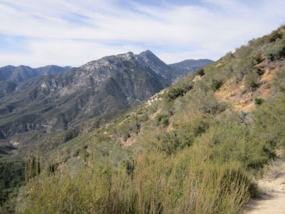
Our spring-like weather has continued here to the end of January, so we decided to try the Upper Bear Creek Trail off of Highway 39 in the Angeles National Forest, just south of the Coldbrook Campground. The Upper Bear Creek trailhead is at 3280 ft., much lower than the Windy Gap trail we've done many times this winter. Since it is lower, and has relatively few trees up to the Smith Mountain saddle, it's a trail best used from October through May and avoided in warmer months. Our hike at midday had a temperature of between 67 to 70 degrees in full sun.

The Upper Bear Creek-to-Smith Mountain portion of the trail is moderate, with an elevation gain of 1900 feet. Already the mountains are turning green and the first wildflowers are blooming. At the saddle, you can choose to continue down into Bear Creek, or go off trail and climb the last 800 or so feet to the peak. We chose the peak. The path is quite steep and required us to do some rock climbing. The view at the top, as can be expected, is spectacular.


Speaking of Highway 39, on the day of our hike the Los Angeles Times ran a story that Caltrans is seeking to abandon the portion of the highway that crosses the San Gabriel Mountains because of the $1.5 million annual cost to maintain it amid frequent landslides, earthquakes and fires. It wants to transfer the responsibility to either the U.S. Forest Service or to Los Angeles County, both of which have declined.

Caltrans spends nearly $13 billion--billion, with a b--to maintain California roads, and it considers abandoning Highway 39 a way to save money (under 2 million--million, with an m).

Caltrans has maintained the road under a special permit since the 1920s. For its part, the Forest Service maintains that if Caltrans abandons the highway, it must, according to the permit, return the road to the natural landscape--meaning to remove it entirely.

Is Caltrans bluffing? Stay tuned.

Sunday, January 8, 2012

The Trailbuilders

Blessed again with some unseasonably warm and sunny weather, we returned to the Windy Gap Trail around Crystal Lake in the Angeles National Forest this weekend.  We came across several volunteers of the San Gabriel Mountains Trailbuilders doing yeoman's work.

These volunteers are the unsung heroes of the local trails: They improve and maintain trails by building bridges and retaining walls, posting signs and mile markers, and keeping the trails cleared of debris. In some cases the debris is a massive dead tree that has fallen across the trail (a "deadfall"), or rocks and boulders that have been shed from the crumbly mountains above. In other cases it's a large and sometimes unfriendly plant that can block a hiker's path. On this day, there were groups removing the deadfalls toward the top of the trail, and groups removing rocks from a slide in the middle of it.

The trails around Crystal Lake have been plagued by deadfalls resulting from the huge Curve Fire in 2002. A tree that burns in a forest fire may leave a dead trunk that remains standing for many years, until it rots to the point of collapse and finally, inexorably, topples over. When a mammoth trunk falls across a trail, a hiker has to choose whether to climb over or under the tree, if possible, or if not, to depart the trail to make a detour around it. Either way, it makes a trail harder and more time-consuming to follow. The Trailbuilders remove each deadfall by tagging it and and eventually returning to dispatch it by chainsaw. The only remaining deadfalls now on the Windy Gap Trail are a few near the very top of the trail.

Rocks are another issue. They fall constantly on the trails as the weather freezes, thaws and deteriorates a mountain throughout the year until parts of it break off and roll on down the canyons. Sometimes the accumulation of rocks simply makes a trail a rough and tricky prospect to cross. But a rock slide can obliterate a trail's retaining walls, or obstruct it so badly a detour can't be made around it.

On our way up the trail, large rocks were being removed by hand from a portion that crossed a retaining wall; on our way back down, the trail had been cleared (see photo below). So many rocks had fallen down the canyon that the retaining wall is barely visible.

Keeping the trails clear and usable might seem like a thankless task, but as hikers, trust us, it's anything but.

Sunday, January 1, 2012

Happy New Year

We got the new year started off on the right foot with a hike up Windy Gap trail in the Angeles National Forest. This trail, which starts about a half a mile from the Crystal Lake campground at 5832 feet, ascends to 7588 feet at the saddle between Mt. Islip to the west and Hawkins Ridge to the east.  The weather was incredible, warm and sunny with the temperature at 67 at our Crystal Lake departure.

We were fortunate to see bighorn sheep twice in December while hiking this area, and a large bobcat fairly close to the Crystal Lake campground. No bighorn sheep this time around, unfortunately. Not even a deer. There were only the smallest traces of snow up the trail, until we reached Windy Gap, where there still remained larger patches on the shady side heading to the Little Jimmy campground. It's usually quite a bit cooler at the gap than on the trail that's sheltered by the mountains, and yes, Windy Gap lives up to its name.

Over Christmas we bought a new camera to try on the trail, something small and light that could document and illustrate our hikes over the seasons. We're very happy with the resulting photos.